Hello map aficionados!
Production of Volume 7 is nearing completion—and inside you’ll find 33 beautiful maps to admire paired with commentaries full of practical design insights. Whether you take that knowledge and apply it to your own work, or simply use it to better appreciate the many thoughtfully crafted things out there in the world, the Atlas is committed to sharing with readers the wide scope of excellent cartography being made today. Sadly, there is only so much we can fit into a single book, and so while we wait for Volume 7, we wanted to highlight some of the honorable mentions from this volume and share even more interesting maps that we think readers will enjoy. Look for a second part on our blog soon!
The comments in this series are the opinions of the editors and do not speak for the authors of the maps, nor do they offer an official Atlas of Design opinion. We simply wish to point you in the direction of some additional well-crafted maps and their authors. We hope you will find them inspiring and encourage you to check out more of their work!
Abigail Rabinovitch
Climbing Her Way to the Top, Janja Garnbret’s Routes in the 2020 Olympics Bouldering Final
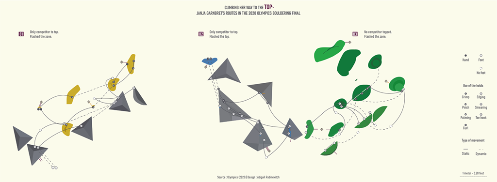
Aaron: This unique design pushes the definition of what a map can be, and communicates the complexity and skill of high-level bouldering. A welcoming simplicity at first glance helps ease readers into what’s really a very complicated series of paths and movements beneath. It certainly got me interested in learning more about the sport! For those curious, you can watch Janja Garnbret’s Olympic performance to compare here, and you can find more of Abigail’s work on X(Twitter) @abigail2154 and LinkedIn.
Federico La Rosa
Monstruos y Leyendas de Rio Negro (Myths and Monsters of Rio Negro)
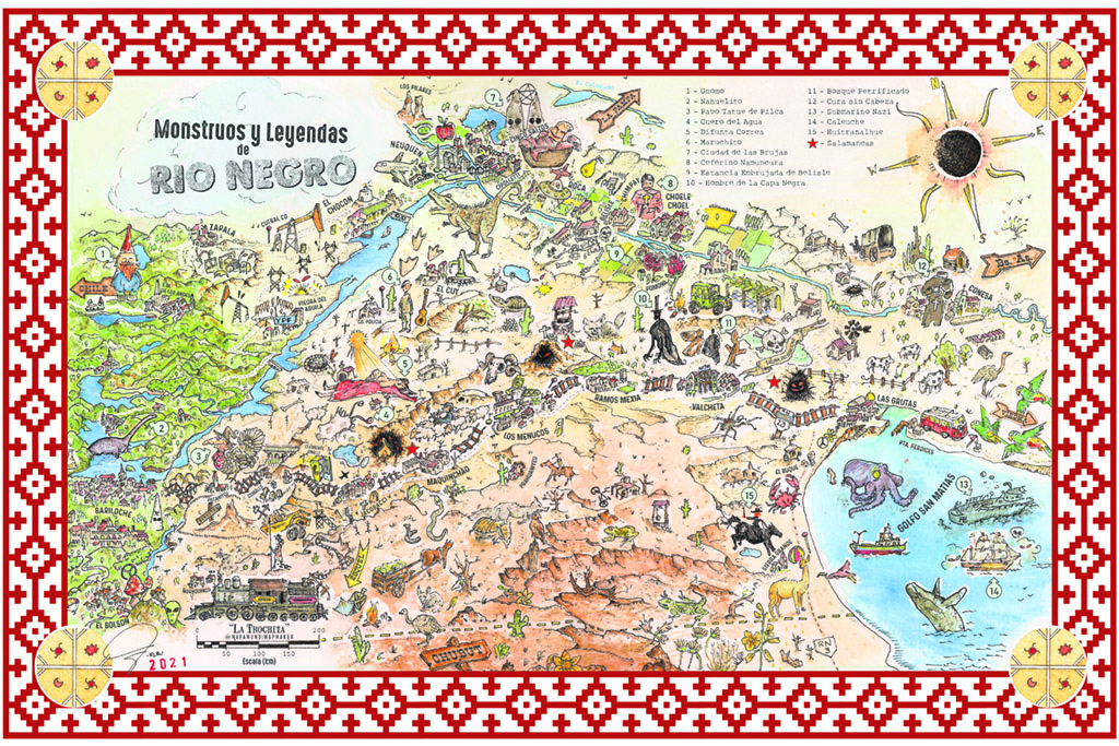
Aaron: There’s a lot to take in with this illustrated map of the Río Negro Province in Argentina. This work of art is absolutely packed with fun and interesting details of local legends and lore, conveying to readers the deep history of the region. Maps typically help us find our way, but this is an easy one to get lost in (in a good way). You can find more of Federico’s work on Instagram @capitanmapamundi.
Helen Cann
A Map of Bolton Fell Moss
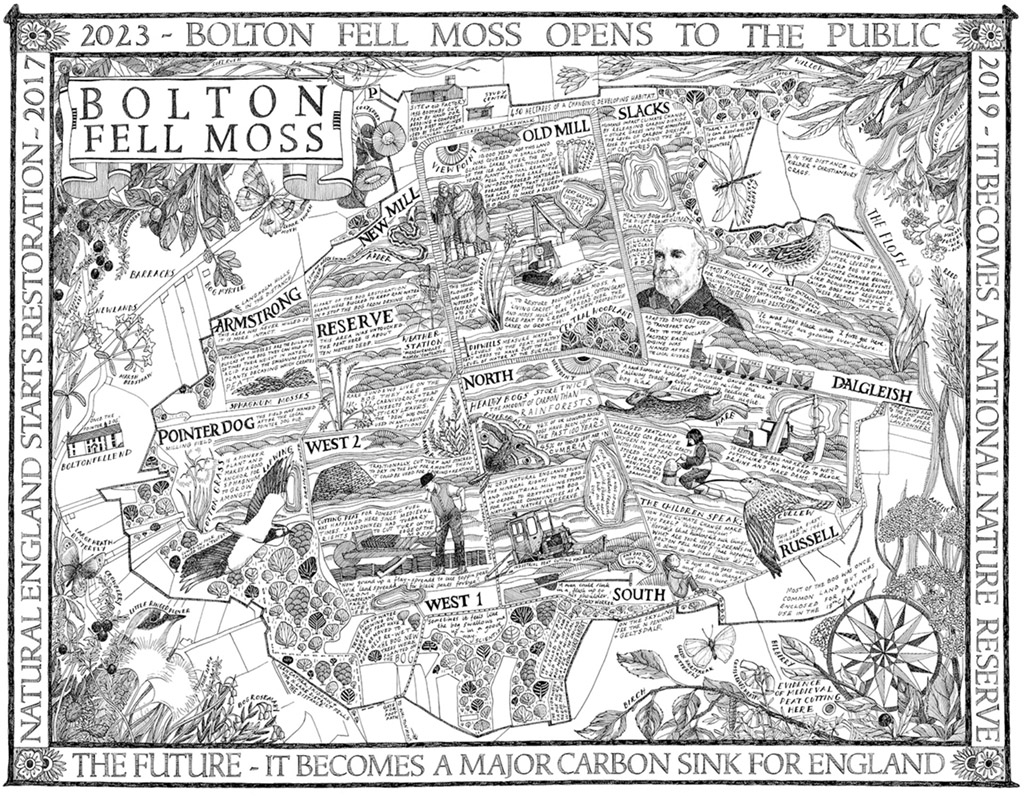
Dan: This richly-detailed, hand-drawn map illustrates the story of Bolton Fell Moss peatland in North West England. The peatland’s milling history, present restoration, and future as a carbon sink are all interwoven into the site’s landmarks and routes in this wonderful map, designed as an informational sign for the Bolton Fell Moss National Nature Reserve. You can read more about the project here and see more of Helen’s work at her website helencann.co.uk or on Instagram @helencannart.
Jon Farber
Ancient Lakes
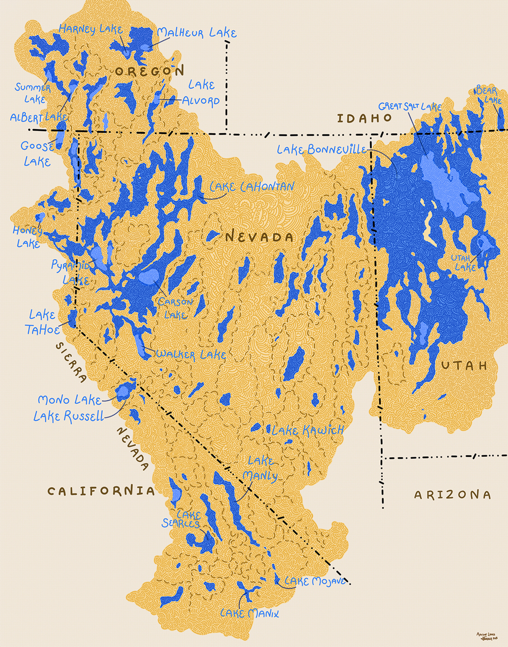
Dan: This bright and colorful map of North America’s Great Basin depicts the large ancient lakes of the Pleistocene epoch overlaid with their modern-day remnants. By connecting past with present, this map reminds us of the earth’s long history and ever-changing nature. It is also a great representation of Farber’s playful and distinctive artistic style, more of which you can see at his website jonfarberart.com.
James Cheshire and Oliver Uberti
Inhumane Flows
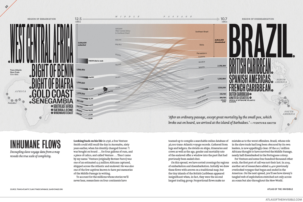
Erin: In an ideal scenario, a flow map would provide ample space for all lines, varying in width, connecting each place directly on the map. But in order to depict the flow of the Trans-Atlantic Slave Trade in great detail here, the traditional map takes a supportive role in the background and the text and flow lines come to the forefront. Combining a map and Sankey diagram reveals the vast scale of the trade and identifies those involved in a clear way. You can find this and many other great maps in their book, Atlas of the Invisible.
Christian Dietrich
Environmental Shocks: Jeopardizing development gains
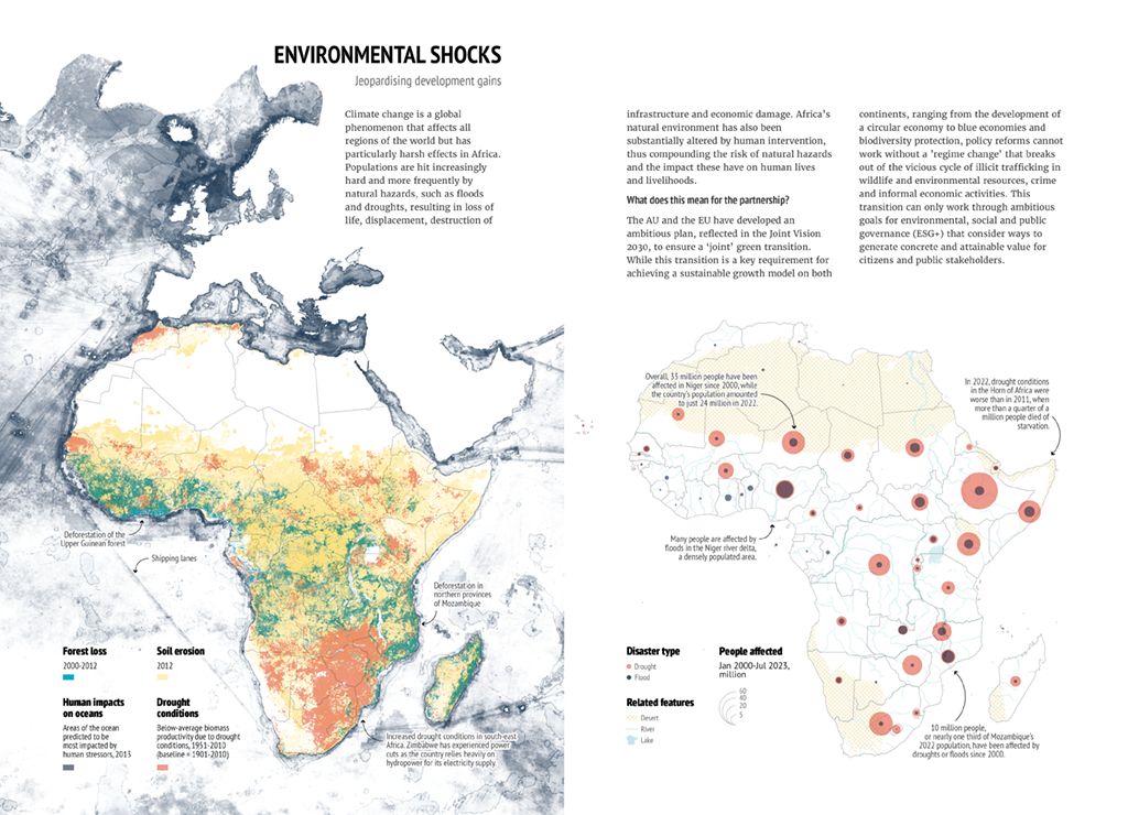
Erin: When looking at this pair of maps, one can easily see how humans have impacted the earth, and how the planet in return can devastate populations through environmental disasters –what the author terms “environmental karma.” This double-page spread, featured in the EUISS Africa Atlas, is a collaborative effort between the African Union and the European Union. I hope that these maps can aid both regions in mitigating the aftermath of historical damage.
Michala Garrison
The 2023 and 2024 Solar Eclipses: Through the Eyes of NASA
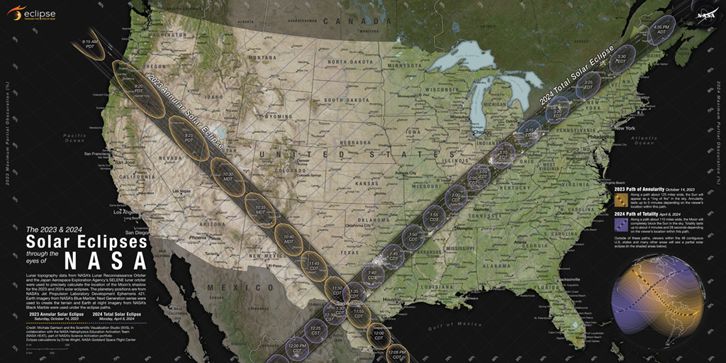
Aileen: Whether or not you used this map to plan your eclipse road trip, Michala Garrison’s map for NASA has been ubiquitous this year. Michala presented it at NACIS last fall but you probably also saw it on Twitter and featured on maps.com. This map provides an education in eclipse viewing and the design details are nothing to scoff at either! Annotations explain both the 2023 and 2024 eclipses, city lights appear in the shadow of the eclipse paths, and a grid helps the reader determine the obscuration at their location. You can find Michala on Twitter @mappinmickie.
Melinda Clarke - Producer, Deborah Young-Monk - Illustrator, Sean Rodwell - Digital Colourist
The Portarlington Map
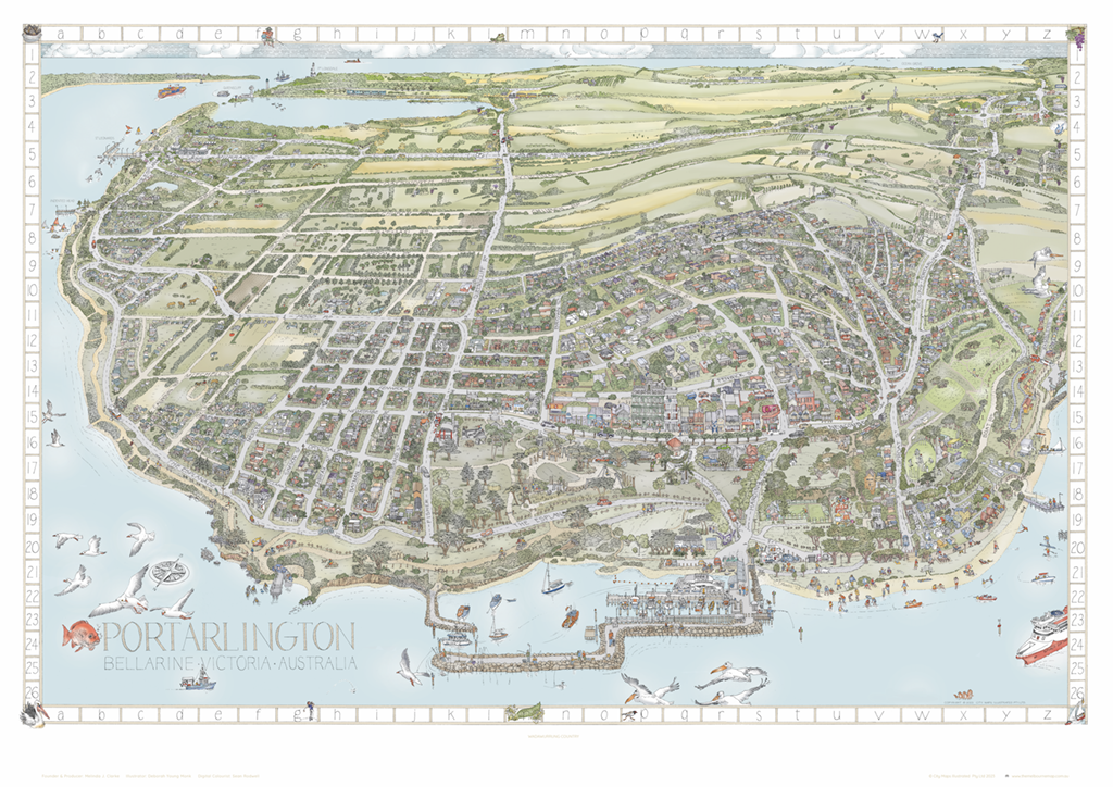
Aileen: After the success of their illustrated map of the Bellarine Peninsula, featured in Volume 6 of the Atlas, Melinda, Deborah, and Sean teamed up again to bring us another fantastically detailed and gorgeously illustrated map of Portarlington. In this map, they gave themselves more freedom in their approach. They eschewed the north-up convention and created an oblique view of this small town, allowing the viewer to get lost in the details amongst the horses, boats, homes, and residents. You can find more of their maps at The Melbourne Map.
Volume 7 is now available for pre-order! Visit our orders page to get yours today!