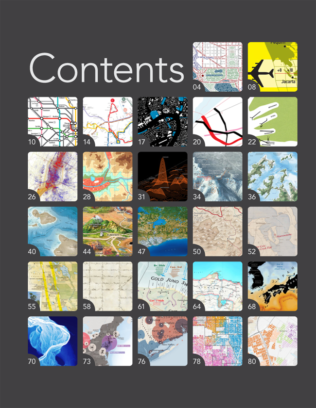
The layout is done, we’ve got copyright releases from everyone, and we’re just a few small adjustments away from delivering files to the press. Now, at long last, we can begin to share with you the book’s contents!
 Click to view PDF of the book’s Table of Contents
The selections for the inaugural edition of the Atlas of Design are:
- Washington, D.C. Ben Sheesley, David Heyman, Andy Woodruff, Mark Harrower / Axis Maps
- Hora Mundial Eduardo Asta and Vincenzo Scarpellini
- U.S. Numbered Highways as a Subway Map Cameron Booth
- Asheville Redefines Transit Matt Forrest and Kate Chanba / Carticulate
- map=yes Aaron Straup Cope / Stamen Design (Map data © OpenStreetMap contributors, CC BY-SA)
- figures INFRASTRUCTURES: At Atlas of Roads and Railways Bieke Cattoor and Bruno De Meulder (Excerpt from: Cattoor, Bieke and De Meulder, Bruno (2011). Figures Infrastructures. An Atlas of Roads and Railways. Amsterdam: SUN, 176p.)
- Portland Finger Plans Ryan Sullivan / Paste in Place
- Locals and Tourists Eric Fischer
- eCartacacoethes Tiberiu Chelcea
- Here Now!: Social Media and the Psychological City Sarah Williams, Juan Francisco Saldarriaga
- Panoramic Map of Mount Washington Alex Tait and Judith Nielsen / International Mapping | Martin Gamache / National Geographic Magazine (The National Geographic Society retains the rights to all maps previously published in National Geographic Magazine)
- Malborough Sounds, New Zealand Roger Smith, Geographx
- Seafloor Map of Hawaiʻi Tom Patterson, US National Park Service
- Northern Arizona Jean-Louis Rheault
- Toronto Metropolitan Region: The Big Picture Chris Brackley / As the Crow Flies cARTography | The Neptis Foundation | The GIS and Cartography Office, Department of Geography, University of Toronto
- Tea Horse Road Martin Gamache, Marguerite B. Hunsiker, Fernando G. Baptista, Mike Reagan, Elaine Bradley, Elbie Bentley / National Geographic Magazine (The National Geographic Society retains the rights to all maps previously published in National Geographic Magazine)
- Oyster Appellations of the Pacific Northwest, Sheet 2 of 4: Northern Puget Sound Adam Wilbert / CartoGaia
- Atlas of Florida’s Natural Heritage: Biodiversity, Landscapes, Stewardship, and Opportunities Tanya M. A. Buckingham / University of Wisconsin Cartography Laboratory | Lou Cross Florida State University—Institute of Science and Public Affairs
- The Ways of the Framers Daniel P. Huffman / somethingaboutmaps
- D-Day Normandy David Deis / Dreamline Cartography
- Empire of Torentine: A Political Map Brian E. Stoll
- Japan’s Swirling Seas Virginia Mason / National Geographic Maps (The National Geographic Society retains the rights to all maps previously published in National Geographic Magazine)
- Willamette River Daniel E. Coe / Oregon Department of Geology and Mineral Industries
- Picturing Urban Decay Derek Watkins
- Two Nations, Over the Air Timothy R. Wallace / University of Wisconsin-Madison
- A Taxonomy of Transitions Bill Rankin / Yale University
- Racial and Ethnic Diversity in Residential Patterns Larry Orman, Alexandra Barnish, Diana Pancholi / GreenInfo Network
You may notice that several people involved in putting the Atlas together, including the editors, are featured in its pages. The judges and editors involved in making the final selections recused themselves where appropriate, both in passing judgment on their own work, and in evaluating that of close colleagues. The world of professional cartographers is a fairly small one, and a lot of people know each other. But we’ve tried to ensure that the process is as fair as any involving subjective aesthetic judgments can be. Not everyone will agree with all of our final selections, but we hope they will find our process sensible.
If you’d like to keep following our progress down the home stretch, including finding out when the volume is for sale, be sure to subscribe to page updates, via RSS or email. Just check out the right side of this page to get set up.